Wednesday, December 30, 2009

Picton - St Arnaud - Section 9 (240km)

Queen Charlotte Track - Anakiwa-Havelock-SH6-Pelorus Bridge-Maungatapu Rd-Track up Pelorus River-Starveall Hut-Old Man Range-Goulter River track to Wairau River, Foot track along SH then SH to St Arnaud

Start of the South Island and a fairly gentle Cook Strait crossing although you wouldn't have believed it from the state of Johno's green face! Ha ha.  Got a boat out to Ship Cove after staying the night in Picton to the start of the Queen Charlotte Track and the first point at which Captain Cook first landed in NZ.  Track has stunning views, beautiful bays and is a well graded wide track; they have just recently opened it up to Mountain Biking so thinking that it would be a good option for a fun adventure later on (always planning the next one!).  Some nice people on the track which made for a nice sociable change to each other! Heaps of Wekas and a horrible possum at 2am with its head firmly planted in our food bag just outside the tent (it didnt even move when Johno put his head out and shouted at it).  

At the end of the Queen Charlotte we were out at Anakiwa to follow a bit of a link footpath on and off to the start of the scenic reserve, a track which runs under the power lines some 400m straight up with some awesome views of Havelock at the top.  We resupplied our food there with our biggest shop yet and 8 night, 9 day stretch.  As our bags were so heavy it was slow progress out to Pelorus Bridge where we camped overnight before heading down Maungatapu Road, a 13km backcountry road stretch to the start of the Richmond Ranges, a 35km section linking to an Alpine section to come out at St Arnaud.  We had a couple of swims in the Emerald Pools of the Pelorus River (summer has finally come!) in between climbing steeply and carefully amongst the tree roots and river to overnight in huts en route.  Chrismas Day saw us walking 'suprise' up to Starveal Hut some 1200m up (great views out to the sea at Nelson and all the surrounding mountains) through bush, along rivers (awesome as was so hot) and through a forest that looked like a tornado had passed through it, trees everywhere; we were very grateful that DOC had cleared the track and rerouted some of it (yes it was that bad) prior to us arriving.

Starting our Alpine section the next day, the wind was a bit gusty in places which made our scrambling sections a bit of a challenge but by the time we were walking on the ridge tops it had died down a bit; however, the cloud that had been hanging around Mt Rintoul all morning had now moved in and we were in and out of cloud for the afternoon.  
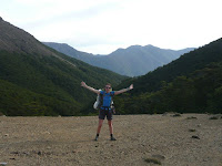
We could still see the markers and the edge thankfully as there were some steep drop offs but we got through to the Old Man ridge and dropped down to the hut there for the night.

Today we waited until mid morning, the weather (cloud and rain) had completely closed in around us overnight at the Old Man Hut some 800m lower than the Mt Rintoul we need to be up at (1700m above sea level).  We decided to head down to the Goulter huts with the plan that we might do a detour back up the other side of Mt Rintoul on a different track the next day thus avoiding the high point but after a further night down the valley and visibility just as bad the next day (if not worse) we decided to head on out of the Richmond Ranges.  The weather was just not behaving, we needed a good clear day to get over Mt Rintoul and the subsequent Red Hills peaks for the full Alpine circuit.  Not having enough food left to wait out more days for a 'good day' that might not come any time soon we navigated our way out to keep on moving South (we'll not get there till December next year otherwise!).  Ended up on a 4WD track alongside the Wairau River then out to the SH where we picked up a foot track under the pylons running adjacent to the road; the weather had turned out to be a beautiful hot day.  We overnighted and walked the last 15km along the highway (in rain again) to St Arnaud where we are now having a day off. - What will the weather do next, we need a nice clear spell for our next section too???

Animals seen: black pig, 2 goats on the ridges, about 10 goats at the Old Man Hut, tails of deer and more goats in the bush

Wednesday, December 16, 2009

Wanganui to Wellington - Section 8 (225km)

Wanganui - Turakina Beach - Bulls - Foxton - Levin - Mt Thompson - Tararuas to Otaki Gorge Road - Otaki Forks -Field Hut - Otaki Forks - Otaki-Raumati Beach - coast walk to Porirua-Colonial Knob-Mt Kaukau- Wellington

From Wanganui we started out with a real boring road walk along SH41 to Turakina, then a further 9km out to the beach. Johno's parents came out to Turakina beach for dinner and met us at the campsite which was great, even better was that they took our backpacks for us so we only had to carry a daypack for 20km! - fantastic!! The next day was a whole day of beachwalking with pretty good weather; it took us back reminiscing to the very start of our walk on 90 Mile Beach.

We got off the beach the Wanganui side of Tangimoana and walked a few km into the small town of Moana Roa to get more water and find out our options for crossing the Rangitikei River (stopping us from walking all the way along the beach). We asked around the 'ghost town' with those that had boats and at the little campsite but no-one could help. One really helpful guy said "can't you just swim"; we hope he wasnt being serious as there was no way in hell we were gonna cross that river. We parked up at the campsite for the night to reconsider our options. After sleeping we decided to road walk to Bulls 20km away (no other option without a boat and virtually no traffic on the road) then get a hitch to the equivalent place further along the beach at Foxton. After reaching Foxton we thought about walking out to the beach and trying to get across our next problem, the Manawatu river and continuing our walk along the beach but after chatting to the locals we figured there wouldn't be much chance of a ride across at this time of day, mid week so rather than waste another day messing around we opted to road walk (nightmare) through to Levin to resupply our food then go onto the DOC campsite at Manakau North Road. What an ugly few days that was, an initial 'lovely beach walk' turned into a long walk along the road due to no boats to cross the river, thankfully we have a few days in the bush ahead of us now.

So the start of the Tararua Ranges was at Mt Thompson, straight up for 700m, the weather was a bit ugly with rain and cloud until the afternoon when it stopped for a bit. The tracks were like rivers in some places and a complete maze to get through resulting in constant GPS use and a bit of backtracking but we got through and out to Otaki Gorge Road eventually.


Danger in Forest: Dodgy dogs growling at you in the forest and owners who can't control them

Action: Get tramping poles in hand, point dog and back away

Result: Dog keeps eye sockets, we keep limbs, owner a bit pissed that we had threatened dogs with sharp spikes on end of poles - Should keep dogs under control!


Walked along the gorge road with diggers clearing slips from the rain off the road then to the start of the track up to Field Hut and the Southern Crossing over the Tararuas, just 3 hours away. Te Araroa's route goes along the beach from Otaki but we wanted to experience some of the Tararuas. However that night in the hut it rained so heavily all night long that it was impossible to even attempt going anywhere until about 10am the next day when we started off to Kime Hut just another 3 hours up before seeing if we could then carry on to Alpha Hut another 4-5hrs after that. Well we got 45 minutes up the mountain, probably about 1000m and only 300m since Field Hut and the wind was attrocious. We could hardly stand up and the mist was very bad making visibility difficult already and with another 500m to climb to the top and me already crouched behind some tussock we decided to return to Field Hut. We thought we might try and give it another go in the afternoon but the wind appeared to be stronger plus some other trampers had come up and told us the forecast 'gale force winds up to 100km/ph and mist not to be clearing anytime soon.

So we stayed put in Field Hut for the night and thought we'd check it out the following day maybe but at 5.30am the following morning it hadn't changed and rather than waste another days food we decided to walk back to the car park and out to Otaki to find another route. Malcolm gave us a ride to Otaki (a guy at the hut also turned back by bad weather but on an alternative route) where we bought another topo map of our new route along the coast (The Te Araroa route) so off we headed again following the coast for the day, picking up the sea wall and various parks all the way into Porirua. We stayed at the camp there, right at the start of the track for the final day of the North Island into Wellington, up Colonial Knob (farmland) down through Spicer Forest, up to Mt KauKau and the massive television ariel then down to Wellingtons Botanical Gardens.


North Island Complete
Celebretary Dinner
3 days off in Wellington
Ferry to Picton then start walking the day after.


Thanks for reading everyone, and keeping up with the armchair reading. Hope its not too boring! Happy Christmas to all

Saturday, November 28, 2009

Te Kuiti to Wanganui - Section 7 (305km)

Te Kuiti- Mangokewa stream and road - Mt Pureora- Bogg Inn Hut-Waihaha Hut- SH41-Kuratau Junction-Tokaanu-Turangi - Tongariro Crossing- Whakapapa-Mangaturuturu Hut - Ruapehu-Ohakune

A funny start at Te Kuiti with the man at the Limeworks company telling us that we weren't allowed along the road through and proceeded to guide us onto a track the wrong side of the river we actually wanted to be on. We decided that perhaps we were on the right track originally and perhaps he didnt agree with access being granted but we got to the Mangokewa Reserve eventually and picked up the Mangokewa River Track, saw lots of goats and Johno most disappointed that he didnt have a gun to improve our dinner for the night. From the river we started our walk to the Herekino Forest which took the whole day I might add but on arrival discovered that the forest had been harvested along with all the track marker signs; there were roads leading everywhere so after having put the tent up in the only bit of native bush in the whole forest for the night the next day decided that it would in fact be quicker to walk back out and down the road rather than try and navigate our way through a demolished forest for the day. Had an interesting time negotiating the bull on the cow race on the way out who instead of going in the opposite direction to us like his bull mates and decided to walk ahead of us until he saw the road gate at the end and realised he was now cornered at which point the bull turned to face us with a very angry look and we jumped over (well Johno jumped over and I had to be yanked over) an electric fence. We had a pleasant two days walk through the Pureora Forest with awesome tracks and a night in both Bog Inn Hun and Waihaha Hut followed by a boring 2 days walk along SH41 to Kuratau Junction where we stayed the night at the back of the Community Hall (permission given of course). Our route from there changed slightly in the fact that we had been permitted to walk from Kuratau through Moerangi Station but the forest surrounding the whole station advised us that we had to submit our intentions to them in writing by email and they would come back to us after their next board meeting. This of course we did not have time for so we decided to walk to Turangi instead (direction West, 20km the wrong way) then get a hitch back to the equivalent distance after our night there but direction South this time. This also enabled us to courier some more shoes from Taupo for Johno who has trashed his already.

So now on the right direction we walked along the road from our drop off point to the start of the Tongariro Crossing at the Ketatahi track. Crikey we had gone from seeing no overnight trampers on any track since Cape Reinga, to 12 hunters the other day to about 250 people and all walking towards us. We were now on the great 'One Day Tongariro Alpine Crossing' We stayed the night at Ketatahi Hut with absolutely stunning views of Lake Taupo and the sacred Ketatahi Hot Springs; we were going to camp but didnt think the tent would like the 70km wind forecast at over 1000m. We awoke to a gorgeous day and managed a good hour walk before seeing anyone else; the Emerald and Blue Lakes were beautiful, sky bright blue and winds attrocious at 70km per hour. We could just about stand up on the top and going into a headwind had to really dig our poles into the ground and keep going to sustain the momentum of moving. It was a bit scary, kept looking down and seeing how close I was to the crater rim. What was more scary though was what some people were wearing, it looked like they were going to a nightclub rather than to climb a mountain of 1900m. We were glad it didnt rain as half of them didnt have any thermals, hat, gloves or rain gear with them.

Stayed in Whakapapa Village for the night before heading out to Mangaturuturu Hut (had to camp as hut was full, its not even holidays yet, whats going on?) and over many valleys and quite a few rivers with awesome views of Mt Ruapehu. Think its the first time we have got our shoes totally wet from the river as opposed to the rain for a long time (not like the South Island). Lovely walk out to the Ohakune Mountain Road where we decided to get Johno's swollen foot checked out at the doctors. Some kind of insect bite revealed an infection, 2 days with leg up to reduce swelling and a course of antibiotics. So I went mountain biking whilst in Ohakune up the Old Coach Road, along the old viaduct (where AJ Hackett did the first bungy) and the railway tunnels - was great. Thanks to Bodhi at LKNZ (former Matai Lodge) for an awesome stay and being my mountain bike guide.


So after our two days off we planned an easy 38km walk to Pipiriki just in case Johno's foot was bad again; it rained from about an hour after we started and was pissing down all day; we had enough about 3pm and decided to find somewhere to put the tent up for the night and as we were walking along the road we came across an old woolshed just off the road in the forest. We took a little look and made a very quick decision that it would be an awesome place to crash for the night so layed our tent on the floor to cover up all the animal shit, gave it a bit of a clean with some old bits of wood and had an awesome shelter with no shortage of rainwater for drinking. You cant even imagine how good it was to be out of the rain. The next day of course was still raining but on we plodded to Pipiriki where we found a shelter for the kayakers there by the Wanganui River. We had to wait there until the next day for the canoes and Dad and Uncle Steve to arrive for our next section - paddling down the Wanganui River and NO its not cheating!!! We have the choice of walking or biking this 80km part of the Te Araroa trail. The following day Dad and Uncle Steve came up with the mail run from Wanganui to Pipiriki, the canoes arrived and we started to pack our waterproof barrels to load into our 17ft Canadian canoes. After some instruction by Yeti Tours we hopped in what was now a pretty swollen Wanganui River from all the rain and off we paddled. We just made it to our first camping ground for the night, The Flying Fox, Ecolodge and put up our tents before the heavens opened yet again. The lovely Annette and John of the Flying Fox let us use one of the beautiful Ecohouses there to cook our dinner and have a lovely hot shower (much appreciated guys, thanks).


The next day the river had risen even higher but the weather was clearing (apparently) so off we went. We had morning tea at Downes Hut then got to our second planned campspot, Hipango Park in just half the day after a pretty difficult sideways manouvre into the jetty which was mostly covered by water and difficult to negotiate with the speed of the river. It looked like it was touch and go for a minute as to whether Mike and Steve were going to end up in the river but they made it round and we were all still dry so that was good.

As we had got there so early we decided to carry on a bit longer and camp further up the river somewhere. The river however was taking us so swifly, and along with the tailwind and outgoing tide we realised we were very close to Wanganui and decided to come in a day earlier than planned (again just in time before the rain started again)! - lucky or what. We then had to take the canoes one by one back to the house on the back of Mikes truck (quite a challenge to put a 17ft canoe on the top of a small Isuzu) to be collected the following day by Yeti. A good trip had by all and we are definitely planning a trip on the upper half of the river soon and dragging a few more Tunnells down with us next time.


We are desperately hoping the summer is coming soon as we think it has rained every day since leaving Hamilton.

Monday, November 16, 2009

Hamilton to Te Kuiti - Section 6 (121km)

Hamilton - Kapamahunga ranges - Pirongia Mountain - back country road walking - SH23 - Kaimango Road - Farm tracks and forest - Mahoe Road - Waitomo Caves - Farmland - Te Kuiti


Day walking out of Hamilton to the Kapamahunga ranges, very funny (for Johno anyway) when my foot got jammed in cow mud and nearly fell over getting it out, was very worried my shoe would be stuck in there and my foot would come out of it. Awesome views out of Pirongia and stayed at our first DOC hut (Pahautea Hut) 954m since starting this walk. We had only walked for about 5 hours but couldnt pass up the opportunity and had been wet the day before so dried everything out in the sun and just chilled - awesome!!

Boggy as ground coming down from the mountain and nearly had another couple of shoe suction actions again. Walked some back country roads with only about 1 car per 2 hours on them, makes you wander why they are there. We were supposed to walk through Mahoe Forest down to Waitomo Caves but couldnt find the start of the track so ended up walking down the road (gravel back country one) for about 20km before picking up a bit of the Waitomo walkway and heading into the village for the night. Farm walked all the way to Te Kuiti where we are staying with Dan and Amanda and the kids for a few nights. Fantastic!!

Tuesday, November 10, 2009

Auckland - Hamilton - Section 5 (170km)

Coast to Coast walkway out of Auckland - Massey/Crosseys track - Mercer - Meremere - Waikato River Walk - Rangiri - Huntly - Hakarimata walkway - Ngaruawahia - Waikato River Walkway - Hamilton

Much road walking for this section, it took us a day and half to get out of Auckland, picked up a couple of walkways and forest tracks and lots more road walking until we got to Mercer where we had to pick up SH7 until getting to Meremere - where we picked up the Rangiriri walkway along the Waikato River and followed the stopbanks and various dairy farms all the way. At Rangiri we stayed at the hotel there and then off we go along the stopbanks alongside the river again until Huntly through to the Hakarimatas then Ngarawhaia and back onto the Waikato and finally Hamilton where Ang and Cesar have kindly put us up for a few nights - awesome guys thanks!!

Monday, November 2, 2009

Waipu to Auckland - Section 4 (183km)

Waipu - Brynderwyn walkway - Mangawhai- Pakiri- Tamahunga Ranges - Dome Forest - Waiwhui-Puhoi- Orewa-Devonport-Auckland


Out of Waipu then through DOC's Brynderwyn walkway where we met Anette and Tom at the Trig Point, a couple from Auckland away for the weekend at their bach in Mangawhai Heads (first people we have met tramping since Ninety Mile Beach). We walked back to the car park with them and then on our own again picked up a farm track to the Mangawhai Cliffs walkway. Stayed with Annette and Tom for the night as they had so kindly invited us and had an awesome roast chook for tea. thanks guys!. The following day we beach walked all the way to Pakiri and stayed at the campground there - only 2 others besides us, all the Aucklanders gone home after the long weekend. Had been a very wet afternoon but cleared up enough to put the tent up quickly. The following day was another wet arse day into Matakana from the Tamahunga track. Matakana is quite a posh town with designer shops and a very expensive supermarket and we looked right out of place in our designer mud splattered rain gear. Headed up the Dome Whaiwhui Forest where we camped the night and the following day met Jim and his wife at the Dome Forest Cafe who said that he had had a couple come through 3 weeks ago doing the Teararoa trail from the USA. We suggested he make a Teararoa hikers board at the cafe which he has done - awesome! Various trails into Moirs Hill Forest then into Puhoi where we had a 3 hour wait due to the tides and a lovely pub lunch before canoeing the Puhoi River down to Wenderholm Regional Park. Its not possible to walk this section as is SH (motorway) so the 8km paddle was a nice change. Decided to camp at the Park for the night before heading out the next day for a walk all the way round the coast to Whangaparoa where Gunter (an avid Teararoa supporter) took us across the Weiti River in his little boat so we could walk the Okura Track then round on the North Shore Coastal Walkway from Long Bay all the way to Devonport and as it was low tide we were able to walk on the beach and round the rocks pretty much all the way. Awesome coastal walk! - Took the ferry from Devonport and we are now resting up in Auckland for a few days.


Birds seen: New Zeland Terns (protected) and Kakariki parrots

Sunday, November 1, 2009

Paihia to Waipu - Section 3 (215km)


Well this was a nice dry section for us, only a few days of showers and rain coat on and off 10 times per day! Nice coastal walk around the bays and out of Paihia then onto the vehicle ferry to cross to Okiato. A mixture of tar seal and logging tracks for the afternoon before heading into the Russel 'Ngaitongo Walkway'. Saw the most awful rubbish tip off the side of the road going straight down into the forest - even cars just dumped over the side - DISGUSTING!!

No streams at the start of the forest and heading into night time but Johno was awesome and managed to suck up a litre of water out of a rain puddle - just enough for a drink for the evening and a little for the following morning. Good job he did as had a 3 hour walk before we got to the stream in the end. Bit of a landslide gone on at the end of the track or rather what was the track, legs are ripped to bits from the gorse and clambering over fallen trees - Johno reckons it ruins his modelling career!! Because of the bush bashing the day before we decided to change the days route and we took the coastal road down to Mimiwhangata coastal reserve rather than through the forest and we are so glad we did - it was the most stunning scenery - we even walked a 32km day (the most so far)


Walked across Whananaki footbridge, the longest in New Zealand before picking up another coastal route heading into the Matapouri Forest where we had to wait (luckily for only 45mins) for forestry operations to finish for the day (didnt fancy a big pine tree on our heads!). Ngururu's campsite no longer exists (nice to find these things out at 6.30pm at night)! so we hitched to Tutukarara to camp for the night (about 4km away). Just so happened that the guy who picked us up was living at the campsite so that was handy. Got another ride back the following morning to that pick up point then various roads into the Mackerel Forest to Patua and our longest day yet at 35km!!! We hadnt planned to walk that long but there was nowhere to really camp for the night. We thought we could stock up on some yummy stuff at the campsite in Patua for the night but found out we were the only ones there and the shop was closed until December where apparently the population of 50 increases to 5000!!!!

Had another change to the Teararoa trail later on leaving Patua as high tide thus not able to walk over the estuary so a bit of road walking before hitting Marsden Point where we managed to hitch a ride on a boat after only a 20min wait with two girls who had been out diving for the day. Across to the oil refinery the other side (bit too deep to wade across) before continuing on the beach through Ruakaka and then Waipu for our day off where we exchanged a nights accommodation for tidying the owners garden for 2 hours - bargain!!

Thursday, October 15, 2009

Ahipara to Pahia - Section 2 (148km)

Ahipara - Herikino Forest - Takahue- Mangamuka - Puketi Forest - Kerikeri - Pahia

After our day off and feeling refreshed we set off again. Into the Herekino Forest and along an old logging track passing some old logging huts very much in disrepair; we camped in the forest for the night at the bottom of the track and scrambled around the bush to find the stream where we could hear the water coming from and desperately needed for the night. That night it pissed down and we woke to find ourselves, well the tent anyway, floating in it. Getting up that day was a challenge, trying to keep our clothes dry whilst taking down the tent and not getting too cold; I would of taken a photo but at the time it really wasnt very funny!! The next challenge was getting up the hill, one step up and one slide back all the way; it did clear up in the afternoon though which was good, at last we can take the rain pants off (so much for thinking we'll take them as an extra, they have hardly been off us so far). Saw a wild pig and her little piglets today; was taking a photo then she starting running at us; you have never heard us make so much noise to make her go the other way - think we woke up the whole forest!

Heading over the Mangamuka track was the next challenge; the track had not been cut going down the other side and because of all the rain and the trees that had inconsiderately fallen in what path there actually was it made for very very slow going, we kept falling into the mud - reckon on about 2km an hour if we were lucky? We also got momentarily lost and had the map, compass and GPS out for about an hour to find only what was right under our noses all along (a nice little orange track marker!) - we put it down to dehydration; all through the forest there wasnt one stream to be found, eventually we succumbed to a puddle of rain! Eventually upon exiting onto SH1 out of the Ratea Forest we then had a 9km walk in the still pissing down weather. Arrived at Mangamuka Marae about 6.30 and still 4km from town. Decided to take up the 3rd offer of a ride that day and jump on the back of a ute and into town to the only accommodation ' the Mangamuka Hotel'..... It was shut!! Luckily the guy who dropped us off is the cousin of Justin who put us up for the night in the old butchery (all related to each other in Mangamuka!). Very very basic but absolutely awesome to be somewhere dry!! He is running the Maori radio station from there, which was really funny and so modern in contrast to where we stayed for the night just next door with the concrete floor - everyone is so hospitable.


The next morning we had to hitch back to the Marae to start the track where we had left off before we could continue walking. Had fun today going through Puketi Forest with a Maori protest shutting the bridge; they are protesting against Juken Nissho and the mess they are making of the forest (their land). The guy was pretty nice to us though and did let us through after we explained we couldnt go the other way as there had been to much rain and the gorge would be too high to go through, he didnt like the idea of us passing but I think he liked the idea of us being drowned in the gorge even less. So after walking over the bridge and then missing our forestry road and having to go back for about 2km we were on our way to Kerikeri - our first real civilization for a while. Easy walking the next day through Waitangi Forest and out to Waitangi House where the Treaty was first signed in 1840 and then into Pahia but we were dragging our arses as feet now causing us issues and very much in need of a day off!!! - still having fun though (I think)!

We are averaging about 20km a day so not bad going so far, some days are obviously quicker than others but if we try and keep to that we should be on target to finish in March.


TIPS: Always look at all possible routes for track markers. Know the difference between 'go past' and 'pass' when reading track notes and always check your compass and refer back to the GPS that you are not carrying for the fun of it!!!


Items Gained: Blisters - 4 - (each). Welts on foot - 1 (Johno), Faith in Humanity - thanks to all who have kindly tried to offer us rides even when we look like drowned rats (NB:we have refused these though)

Thanks: to Justin at Mangamuka for putting us up for the night

Wednesday, October 7, 2009

Cape Reinga to Ahipara - Ninety Mile Beach - Section 1 (111km)


Cape Reinga - 90 Mile Beach - Ahipara

Well the tiki tour has finally started. Got a tour bus up to Cape Reinga lighthouse via the Kauri Kingdom and started tramping in the afternoon. A gentle walk in lovely sunshine over the cliffs and down to the beach, a good start as we had been expecting rain! Saw only one other person walking the beach that day, and she needed help as had lost her map and couldnt see the very obvious marker posts around the corner of the hill! The only others we saw were 3 others as we put up our tent that night just at the start of Twilight Beach, camping out in their van.

Lesson of the day: Always keep your map with you!


Beach, Beach and more Beach.

Bus driver that took us up to Cape Reinga was awesome today, he took a load of passengers down the beach and threw a handful of lollies out of the bus door to us. Thanks Allen! Camped in the Sand Dunes that night after passing a perfectly good grassy campsite only an hour before. Sand for dinner anyone?? Johno woke up the next morning and put his head out of the tent to find a big black horse snorting at him; our first wild horse except that I didnt get to see it. Saw lots of other horses though so its ok now. Also saw pheasants and an NZ hawk. Had a long wet day on day 3 and sheltered out that night in the forest but luckily dried off the next day as only showers. Stayed at the motor camp at Waipapakauri Beach for the last night before Ahipara as Johno has man flu and the wind is really strong now. Last stretch along 90 mile beach to Ahipara 103km Section 1 complete!. AWESOME!!!

Items lost - sunglasses and 1 tent peg!

Kiaora

We hope you enjoy the 'Tiki Tour' with us

"One life.... LIVE IT!"

About Us

My photo
Christchurch, New Zealand
Tramping 3000km You're doing WHAT? WHY? We might ask ourselves the same question on numerous days throughout the next 5 months but we have set ourselves this challenge and may just have to grin and bear it at times but most of all ENJOY it! We can't wait. See you soon......

Follow the Progress of the Te Araroa Trail at